


LASER scanners and LiDARs for underwater operations:
A resource guide (Page 3 of 3)
Videos
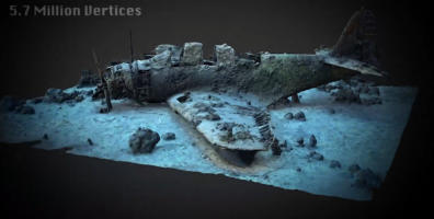
3 - 3D at Depth, Inc. - Preserving History: US Navy Douglas TBD-1
Devastator
See above the description of “3D at depth” company
Note: This video shows how photogrammetry, when combined with LiDAR,
can be used to record the exact proportions of an immersed object and
display them in a 3D image that can be rotated in any direction.
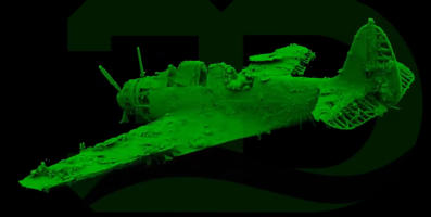
4 - 3D at Depth, Inc. - Underwater LiDAR archiological scann Devastator
plane
See above the description of “3D at depth” company
Note: This video shows how the U.S. Navy Douglas TBD Devastator torpedo
bomber above appears when LiDAR is used alone.

Click on the
octopus to return to
the top of the page
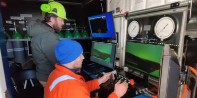
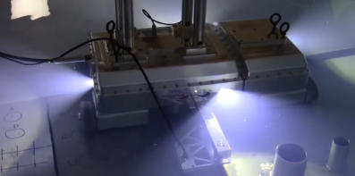
37 - Universitat de Girona - 3 D laser scanner for underwater manipulation
This work, which makes precise manipulation possible by correcting the optical
distortions caused by water refraction, comes from the VICOROB institute at the
University of Girona, a leading center in underwater robotics.
Address: Plaça Sant Domènec, 3, Edificio Les Àligues, 17004 Girona, Catalogna,
Spain
Phone: +34 972 418 046
Email: informacio@udg.edu
Website: https://www.udg.edu/en
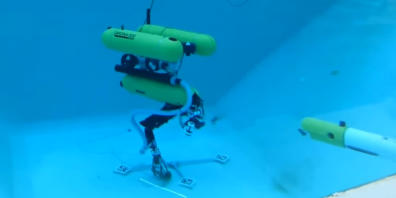
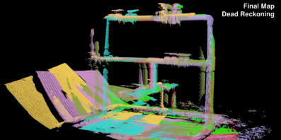
38 - Universitat de Girona - Inspection of an underwater structure using
point cloud SLAM with an AUV and Laser
Scanner
The Universitat de Girona is described above
This video describes a method for underwater inspection where an
Autonomous Underwater Vehicle (AUV) equipped with a laser scanner collects
high-resolution 3D point clouds of subsea structures. This process uses point
cloud SLAM (Simultaneous Localization and Mapping) to create detailed virtual
maps of underwater assets, enabling precise inspection even at significant
depths. The laser scanner operates by time-of-flight measurement of laser pulses,
allowing millimetric-resolution 3D data collection.
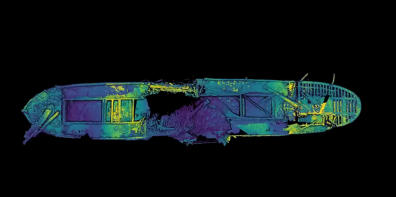
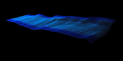
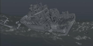
39 - Voyis - 3D point Cloud Model of the Bluesfields shipwreck
Voyis (formely 2G Robotics) is a Canadian company specializing in underwater
optical imaging and laser scanning technologies.
Headquarters: 120 Randall Drive, Unit E, Waterloo, ON N2V 1C6 - Canada
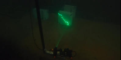
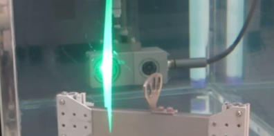
Parent company: Covelya Group
Website: https://voyis.com
Phone: +1 (519) 489-0005
This video is a digital 3D scan of a sunken ship, made from data points:
The shipwreck appears as millions of tiny dots floating in space, each with a
precise 3D coordinate, that together form the full shape of the wreck.
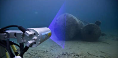
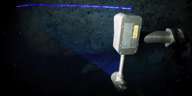
40 - Voyis - Underwater Imaging and laser scanners
Voyis company is described above.
This video explains how laser scanner are used to capture detailed underwater
images and measurements where visibility and access are limited.
41 - Voyis - Cave scanning with an underwater laser scanner - 3D mapping
with lasers!
Video authors: Stephen Daire, Marcelin Nebenhaus, Nathalie Gibb
This video showcases the use of laser scanning technology, specifically LiDAR,
to create detailed 3D maps of underwater cave systems.
42 - Voyis - Underwater Laser Scanning - Bridge Scour Experiments and
Sediment Analysis
This video demonstrates how scanning helps researchers evaluate sediment
deposition or removal to quantify changes in bed elevation and shape over
time. Therefore, it proves that this technology can be used to support safer
bridge design and maintenance strategies.
43 - UVision ApS - Revolutionizing Underwater Inspection UVision 3D
Scanning solution
UVision ApS specializes in the development of underwater 3D scanning systems
for inspection and digital twin generation. It is involved with the European
Space Agency
Headquarters address: Højbro Plads 10
1200 Copenhagen Denmark
Website: https://uvision.dk
Mail: mortenbeier@uvision.dk
+45 26 80 01 31
This video highlights the capabilities and advantages of the UVision 3D scanning
solution. Note that this system is not a LASER scanner, but an underwater 3D
photogrammetry / stereo-vision camera-based system.
44 - Robotics group at Julius-Maximilians-Universität Würzburg -
Towards an Underwater 3D Laser Scanning System for Mobile
Mapping
Robotics group at Julius-Maximilians-Universität Würzburg is located at the
Hubland Campus (South), Würzburg, Germany, and is part of the university’s
Department of Computer Science
Website: https://www.informatik.uni-wuerzburg.de/robotics/
Email: l-info17@informatik.uni-wuerzburg.de
This video presents a prototype system for creating high-resolution 3D maps
underwater using laser scanning. Its main goal is to enable mobile mapping,
meaning the scanner can move while capturing 3D data.
45 - Newton Labs - M200UW Underwater Laser Scanner Demonstration
Newton Labs is a U.S.-based technology company specializing in advanced
machine vision, underwater laser scanning, and robotic inspection systems,
headquartered in Renton, Washington. They provide solutions for nuclear
power, marine, aerospace, and industrial sectors.
Headquarters: 11521 183rd Place SW, Renton, Washington 98055, USA
Website: https://www.newtonlabs.com/
Email: info@newtonlabs.com / sales@newtonlabs.com
Youtube channel: youtube@newtonlabs5882
This video demonstrates that the M200UW laser scanner can create highly
accurate 3D models underwater and can be used for vessel inspection, nuclear
reactor internals scanning, and pipeline and various structures measurements.
46 - Newton Labs - Underwater Robot - Nuclear Inspector
Newton Labs is described above.
This video, which complements the one from the same company mentioned
above, showcases the M200UW laser-scanner robotic inspection system, which
has been adapted for inspecting nuclear reactor vessels.
47 - Norsk Remote sensing - Shipwerck scaning (LiDAR)
Norsk Remote Sensing utilizes LiDAR technology alongside innovative Digital
technology to acquire accurate, detailed data on any subject or location.
Headquarters: Southwest Washington state - USA
Website: https://norskrs.com/
Email: norskscanning@gmail.com
Youtube channel: @NORSKscanning
This video shows how a recently sunken small vessel appears through the
technologies used to detect it.
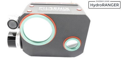
48 - Phoenix LiDAR Systems - Introducing hydroRanger from phoenix
LiDAR systems
Phoenix LiDAR Systems specializes in advanced airborne LiDAR mapping
solutions, including bathymetry
Headquarters: 2113 Wells Branch Pkwy Suite 4000, Austin, TX 78728, USA
Website: https://phoenixlidar.com/
Phonel: +1 (323) 577-3366
This video presents the hydroRanger, an aerial system specifically designed for
bathymetric surveys.
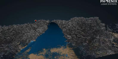
49 - Phoenix LiDAR Systems - Lidar mapping through water with
HydroRanger
Phoenix LiDAR Systems company is described above
This video shows the capabilities of the hydroRanger bathymetric system
described in the video above.
50 - INSITE Solution / NV5 Geospatial - Scott Venables Interview:
Capturing Underwater Geospatial Data using Lidar
INSITE Solution is a company that develops cloud-based, geospatially enabled
data management platforms.
Headquarters: 208 N. Market St., Suite 175, Dallas, TX 75202, USA
Website: https://insite.net
Email: info@insite.net
Phone: +1 (214) 800-4333
NV5 Geospatial provides comprehensive geospatial solutions, including:
Airborne LiDAR and topobathymetric surveys, remote sensing for environmental
monitoring, infrastructure planning, and coastal management, and end-to-end
services from data acquisition to analytics and visualization.
Headquarters: 200 South Park Road, Suite 350, Hollywood, FL 33021, USA
Website: https://www.nv5.com/geospatial
Phone: +1 (954) 495-2112
Scott Venables is an Account Manager at NV5 Geospatial, a leading provider of
end-to-end geospatial solutions.
In this interview, he highlights how topobathymetric LiDAR technology enables
precise mapping of underwater and near-shore environments, offering new
capabilities for geospatial data collection in flooded areas, coastal zones, and
shallow waters.