


LASER scanners and LiDARs for underwater operations:
A resource guide (Page 1 of 3)
LASER stands for ‘Light Amplification by Stimulated Emission of
Radiation’. It is a highly coherent, monochromatic (single-wavelength),
and directional beam of light emitted by a specific device through a
quantum-mechanical process. Unlike ordinary light, which spreads in
all directions and contains many wavelengths, LASER light has the
following properties:
•
Coherent - All waves are in phase with each other.
•
Monochromatic - It consists of a single, precise wavelength (color).
•
Collimated - It travels in a tight, parallel beam with minimal
divergence.
•
Intense - A lot of energy must be concentrated in a small area to
produce a beam of light with these characteristics.
The creation of a LASER can be understood through the following key
concepts and steps:
1.
Energy levels and photon emission:
Electrons in atoms occupy specific, discrete energy levels. When
an electron absorbs energy, it can move from a lower-energy
level, commonly called the ‘ground state’, to a higher-energy level,
also called the ‘excited state’.
This excited state is temporary because it is unstable. Therefore,
when the electron returns to a lower energy level or the ground
state, it releases the absorbed energy as light (a photon). This
light has specific wavelengths, unique to each element, producing
an emission spectrum.
2.
Stimulated emission and LASER light:
According to Einstein’s theory, an excited atom struck by a photon
of the right energy can be stimulated to emit a second photon,
which is identical in wavelength, direction, and phase to the first
one. This process creates a cascade of identical photons,
producing coherent light.
Enough energy should be “pumped” into the medium to create the
process above, so that more atoms are in the ‘excited state’ than
the ‘ground state’, which is called “population inversion”. This is
achieved using electricity, another light source, or chemical
reactions.
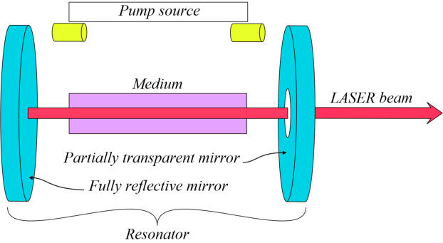
3.
LASER resonator setup:
The gain medium is placed between two mirrors: one fully
reflective and one partially transparent. Photons bounce back and
forth, stimulating more emissions, building an avalanche of
coherent light.
The partially transparent mirror allows a fraction of the amplified
light to escape as the LASER beam.
Introduction to LASER: Meaning and Creation Process
LASER Classification by Wavelengths (colors)
LASERs are commonly categorized by their emission wavelength, which
may be visible or invisible, and are expressed in nanometres.
•
Visible LASERs include the following spectrum of colors that range
from 380 to 700 nm (380 nm and 700 nm being the boundaries
between non-visible and visible lights):
- Violet is emitted by wavelengths from 380 to 450 nm. LASERS
emitting such wavelengths are used for high-density optical data
storage (e.g., Blu-ray players), fluorescence microscopy, biological
imaging, and counterfeit detection.
- Blue emits wavelengths from 450 to 495 nm. These wavelengths
are used for laser pointers and displays, medical applications such
as phototherapy, data storage, high-resolution printing, underwater
imaging and scanning (particularly where water clarity is high),
and high-resolution metrology.
- Green is emitted at wavelengths from 495 to 570 nm. It is
commonly used for laser pointers because of its high visibility to
the human eye, laser light shows and entertainment, alignment
and surveying tools, bathymetry (aerial and underwater),
measurements (in air and underwater), as well as medical
treatments such as photocoagulation in ophthalmology.
- Yellow is emitted at wavelengths between 570 and 590 nm. These
LASER lights are often used for dermatological treatments and
various scientific research.
- Orange light is emitted at wavelengths from 590 to 620 nm and is
used for a few medical applications. It must be noted that it is a
relatively less commonly used range compared to others.
- Red is emitted at wavelengths from 620 to 700 nm. These
wavelengths are commonly found in laser pointers and barcode
scanners, optical communication, printers, CD/DVD players,
photodynamic therapy, and other medical applications.
•
Non-perceived colors include:
- Ultraviolet (UV), whose wavelengths are < 380 nm, is commonly
used for sterilization and semiconductor lithography
- Infrared (IR), with wavelengths > 700 nm, is commonly used for
detection, telecommanding, and other telecom applications.
•
To summarise, on the topic of this presentation, LASER colors used
for bathymetric and underwater applications are blue and green:
- Blue lasers are sometimes preferred for specific underwater
imaging or scanning tasks, particularly where water clarity is high.
- Green lasers are a common choice for underwater operations
because they balance well with water penetration and detector
sensitivity.

LASER scanners and LiDARs
“LASER scanners” and “LiDAR (Light Detection and Ranging)” are LASER-
based measuring and monitoring tools whose terminology is often
confused in marketing and job presentations, leading to
misunderstandings about their precise definitions and applications. This
confusion typically arises because both tools employ the same basic
principle described above. However, the way this principle is applied
differs based on the specific purpose for which each tool is designed.
To resolve this confusion it is necessary to consider the principles used
to calculate distances and reconstruct 3D point clouds.
•
Time-of-Flight (TOF) Measurement Systems:
These systems measures the time it takes for the laser pulse to
travel to a surface and back: A laser pulse is emitted, and the
scanner measures the time it takes for the pulse to return after
reflecting off the surface targeted. The distance is then calculated
using the speed of light and the formula “(speed of light x round trip
travel time) / 2 “. This is done through a LASER source that emits
millions of pulses per second that are bounced off a mirror rotating
at high speeds which covers the full field of view. When a pulse hits
an object, the light scatters, and a portion of it reflects back toward
the scanner’s sensor. Usually, the scanner head rotates 360°
horizontally while the mirror rotates vertically, creating a spherical
capture of the surroundings.
Systems using this principle of distance calcuation are to be
classified “ LiDARs”
We can refer 3 categories of LiDARS:
- Terrestrial LiDARs are used in air only. They exploit wavelenghts
from 785 nm to 1550 nm, and are used in construction, urbanism,
monument monitoring, archeology, mapping and similar activities.
They can be installed at ground level, or on aerial vehicles,
depending on the work to be performed.
- Bathymetric LiDARs are typically mounted on aerial platforms
(aircraft or drones). Unlike terrestrial LiDARs, they use a
dual wavelength system integrated into the same instrument:
1) The infrared/near-Infrared (NIR) channel (approximately 1064
nm) measures the water surface, similar to terrestrial LiDAR.
2) The green channel (approximately 532 nm, within 495–570
nm) penetrates the water column to measure the bottom of
rivers, lakes, or coastal seas.
The system calculates the depth by subtracting the distance to the
water surface (measured by the infrared channel) from the
distance to the bottom (measured by the green channel). This
system is effective in clear water to a depth of about 50 meters.
However, its performance decreases in turbid water due to
scattering and absorption.
- Underwater LiDARs use the same principles than terrestrial
LiDARs excepth they use green and blue wavelenghts (450 to 570
nm). it must be noted that operational scanning distances vary
from 1-3 m in turpid waters to up to 30 m in very clear waters
It is worth noting that the refraction of water must be taken into
account with Bathymetric and underwater LIDARs. This is done
using Snell’s law, which describes how light bends when it passes
from one medium to another for Bathymetric LIDARs, and adjust
TOF calculations for slower light speed and window refraction
(refractive index of water =1.33, instead of 1.0003 in air) for
underwater LiDARs.
•
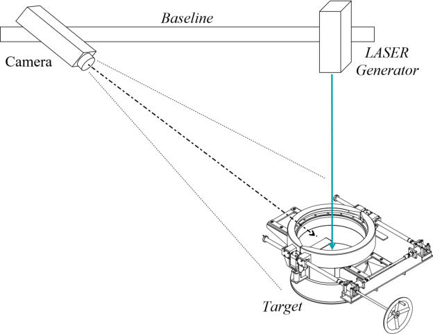
LASER Scanners Utilizing Triangulation Calculations:
This distance calculation principle, mainly used for underwater
LASER scanners, involves a laser that emits spots or lines onto a
target, and a camera or position-sensitive detector that views the
spot from a known offset angle. Unlike time-of-flight (TOF) systems,
the emitter and detector in this setup are not collinear, with typical
baselines ranging from a few centimeters to several tens of
centimeters, depending on the equipment.
By utilizing the known baseline between the emitter and the detector,
the angle between the emitted and received lines can be measured
to form a triangle. This enables the distance to the laser light to be
calculated using the triangulation formula.
It is important to note that since the system is designed for
underwater use, the triangulation geometry is pre-calibrated for the
refractive index of water. This calibration allows the camera or
detector to account for the displacement of the spot caused by
refraction.
Operational distances to the target are typically less than 5m in clear
water. However, these systems generally achieve an accuracy of
better than 1 mm, unlike TOF-based systems.
In addition to the definitions and operating principles mentioned above,
it is essential to consider the history of LASER discovery and the
development of the tools this article discusses (LiDAR and underwater
LASER scanners) to better understand their use, chronology, and
possible near-future evolution.
It is worth noting that, for convenience, only the main steps and
scientists involved in the development of such research are mentioned.
•
Initial theories and research:
Max Planck (1858-1947) proposed that energy is emitted in discrete
packets called quanta, laying the groundwork for quantum
mechanics in his paper "On the Law of the Energy Distribution in the
Normal Spectrum," first published in German in 1901.
Albert Einstein then theorized the principle of LASER in his 1916-
1917 paper "On the quantum theory of radiation", built on Max
Planck's work. The phenomena described by Albert Einstein were
confirmed by Rudolf Ladenburg (1882-1952) in 1928.
Postwar fundamental research was undertaken in the USA, UK,
France, Germany, and the Soviet Union to advance Albert Einstein's
theory. Among the numerous research undertaken, we can note the
laboratory demonstration of the theory of Albert Einstein by Willis E.
Lamb (1902-1988) & Robert C. Retherford (1921-?) in 1947, and the
method for optical pumping (see the explanation of LASER) proposed
in 1950 by Alfred Kastler (1902-1984).
•
Chronological development of LASER technology:
Theodore Maiman (1927-2007), an American physicist at Hughes
Research Laboratories, built and operated the first working laser in
1960. Other researchers, including those at the French Centre
National d'Études des Télécommunications (CNET), contributed to the
development of the first semiconductor laser in 1962. Additionally,
German teams at the Technical University of Berlin also built early
lasers. Similar research has been conducted in various countries,
including the Soviet Union (now the Russian Federation), since the
1960s.
LiDAR (Light Detection and Ranging) technology emerged following
Maiman’s 1960 demonstration and rapidly evolved, with early
prototypes emerging soon after. Throughout the 1960s and 1970s,
key innovations included mechanisms to steer laser beams across a
field of view, the use of highly sensitive detectors such as avalanche
photodiodes (APDs) and photomultiplier tubes (PMTs), and methods to
generate extremely short, high-intensity laser pulses. Furthermore,
advances in electronics and miniaturization during the 1990s led to
the development of a variety of portable terrestrial scanners.
The first LiDAR systems for underwater imaging were developed by
the US Navy to address the limitations of the existing SONARs (Sound
Navigation and Ranging) for tasks that require precise imaging.
Among these developments, note Fraunhofer IPM's (Germany) early
pulsed time-of-flight systems for subsea use. The company "3D at
Depth" (USA) demonstrated the first subsea scanning LiDAR in 2009,
with ROV-integrated prototypes by 2012.
Development continued with the development of commercial
underwater LASER scanner systems (see the description above), in
addition to those made on underwater and bathymetric LiDARs. As
an example, recent projects include research by the Swiss Center
for Electronics and Microtechnology (CSEM) and the Institut Français
de Recherche pour l'Exploitation de la Mer (French Research Institute
for Exploitation of the Sea), commonly called IFREMER, for seafloor
mapping (2025) and green-wavelength systems penetrating 10-
20m in turbid water.
While LiDAR had been used for scientific and military applications for
decades, its most transformative commercial application emerged
from underwater vehicles used for mapping and inspections, both
offshore and onshore, and in sensitive facilities such as nuclear
plants.
•
Advantages and future progress
Underwater LiDAR and LASER scanners enable more effective
operational planning, depending on the project, and allow continuous
monitoring and imaging of ongoing operations. Their 3D, high-
resolution images provide greater detail of inspected elements and
can quickly and faithfully represent targeted objects. Also, the
development of low-cost aerial vehicles enables rapid bathymetric of
shallow mapping areas at reasonable cost, producing results similar
to those obtained underwater with small or medium autonomous
vehicles and divers.
The evolution of these tools is therefore tied to improvements in
sensor quality and performance, as well as to better hardware
integration, often driven by miniaturization.
Future improvements may also stem from software advances that
enable fusion of data from these tools with information from other
systems, such as SONARs and photogrammetry described earlier in
this section, improving accuracy under variable conditions. That
could result from their systematic integration into underwater
vehicles alongside other systems. This fused data may also be
transmitted to divers’ helmets via systems such as the Diver
Augmented Vision Display (DAVD), allowing a diver to directly view
images captured during his dive, increasing awareness of the details
of the piece being worked on.
History, advantages of these tools, and future evolution
The Newton Labs M3200UW and
M310UW are laser scanners
designed to operate at depths up
to 3200 m and a maximum
distance of 5 m from the target.
They produce scans with a
resolution of 0.02 mm and can be
operated from ROV/AUVs as well
as from fixed stations.
The Kraken Robotics Subsea LiDAR is
designed to operate to depths of up to 4000 m
and at ranges of 1 m to 45 m from the target,
depending on water turbidity.
Its single-point operational precision ranges
below 2.5 mm, and it achieves sub-millimeter
precision in aggregated measurements.
It can be installed on ROV/AUVs operating in
stationary or dynamic mode, as well as being
mounted on a tripod deployed by divers.
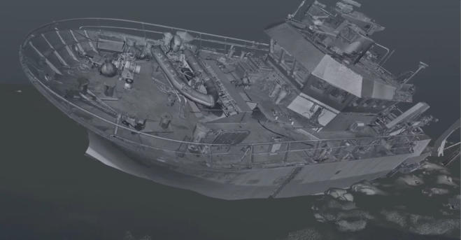
LiDAR-based view of a shipwreck by Norsk Remote Sensing, a
company headquartered in Southwest Washington state, USA, known
for using LiDAR systems alongside innovative digital technologies to
acquire accurate, detailed data on any subject or location.
Website: https://norskrs.com/
Manufacturers
A - Barthymetric LiDARs
This directory provides addresses of known manufacturers offering at
least one of the following LASER-based tools previously described:
- Bathymetric LiDARs
- Underwater LiDARs (Time-Of-Flight)
- Underwater LASERs (triangulation)
As our domain of intervention is underwater, terrestrial manufacturers
are not included in this list.
Please note that this directory is intended to provide a general overview
of existing manufacturers for guidance purposes only and does not
aim to be exhaustive. Some manufacturers may be missing because we
could not find them or because there is no clear evidence that they
offer bathymetric or underwater devices. Additionally, it's important to
recognize that this market is rapidly evolving, which can result in the
emergence of new companies or the absorption of existing ones by
major economic groups in our industry and beyond. Lastly, please be
aware that we have no agreements with the manufacturers listed here.
1 - RIEGL Laser Measurement Systems GmbH:
This company, initially specialized in terrestrial and aerial LiDAR, offers two
bathymetric LiDAR models. No underwater LiDAR or LASER scanner is offered.
- Headquarters: Riedenburgstrase 483580 Horn, AUSTRIA
- Phone: +43 2982 4211
- Email: office@riegl.com /
- Website: https://www.riegl.com/en
2 - Leica Geosystems AG (part of Hexagon AB)
The Leica "CoastalMapper" is presented as a new generation of airborne
bathymetric LiDAR, said to deliver 250% higher survey performance than previous
generations. No underwater LiDAR or LASER scanner is offered.
- Headquarters: Heinrich-Wild-Strasse 201, 9435 Heerbrugg, St. Gallen,
Switzerland
- Phone: +41 71 727 3131
- Email: media.geo@leica-geosystems.com
- Website: https://leica-geosystems.com/
3 - YellowScan
YellowScan offers an UAV-mounted bathymetric LiDAR system for shallow-water
mapping (0–18 m depth). No underwater machines are offered.
- Headquarters: 525 Avenue Saint Sauveur du Pin, 34980 Saint-Clément-de-
Rivière, France
- Phone: +33 4 11 93 14 00
- Email: https://www.yellowscan.com/contact/
- Website: https://www.yellowscan.com/
4 - Teledyne Optech (Teledyne Geospatial)
Teledyne Optech offers the “Fathom”: A topo-bathymetric airborne LiDAR system
that merges topographic and bathymetric measurements with co-registered
multispectral imaging. No underwater devices are offered by this manufacturer at
the time of the website check.
- Headquarters: 300 Interchange Way, Vaughan, Ontario, L4K 5Z8, Canada
- Phone: +1 905 660 0808
- Email: https://www.teledyneoptech.com/contact
- Website: https://www.teledyneoptech.com/products/airborne-lidar/fathom
5 - Phoenix LiDAR Systems
Phoenix LiDAR Systems offers a wide range of airborne mapping LiDARs, including
the HydroRanger, which provides dual-purpose topographic and bathymetric
measurements for shoreline systems.
- Headquarters: 2113 Wells Branch Parkway, Building 1, Suite 4000, Austin, TX
78728, USA
- Phone: 1 (323) 577-3366
- Email: info@phoenixlidar.com
- Website: https://www.phoenixlidar.com/
6 - LSLiDAR (Leishen Intelligent System Co., Ltd.)
This company, involved in the space industry, offers an underwater mapping LiDAR
system for airborne and shipborne use (MD 01).
- Headquarters: Building R, Shasi Dongbao Industrial Zone, Shajing Street, Baoan
District, Shenzhen, Guangdong, China
- Phone: +86-0755-23242821
- Email: sales@lslidar.com
- Website: https://www.lslidar.com/
7 - Areté Associates
This company, involved in the US space and defense industries, offers LiDAR
systems designed for advanced hydrographic surveying and target detection. Built
for seamless integration with tactical-class Unmanned Aerial Systems (UAS).
- Headquarters: 9301 Corbin Avenue, Suite 2000, Northridge, CA 91324, USA
- Phone: +1 (818) 885-2200
- Website: https://arete.com/ - https://arete.com/products/pills/
B - Underwater LiDARs (Time-Of-Flight)
1 - Fraunhofer IPM
This manufacturer offers an underwater LiDAR system (see “Underwater
infrastructures” on their website).
- Headquarters: Georges-Köhler-Allee 301, 79110 Freiburg, Germany
- Phone: 49 761 8857-0
- Email: info@ipm.fraunhofer.de
- Website: https://www.ipm.fraunhofer.de/en
2 - Kraken Robotics Inc. (formerly includes 3D at Depth)
Kraken Robotics became an provider of underwater LiDAR systems since the
acquisition of 3D at Depth in 2025.
- Headquarters: 189 Glencoe Drive, Mount Pearl, NL A1N 4P6, Canada
- Phone: +1 709 757 5757
- Email: https://www.krakenrobotics.com/contact/
- Website: https://www.krakenrobotics.com/
C - Underwater LASERs (triangulation)
1 - Savante Subsea Lasers
Savante Subsea Laser is known for offering high-precision 3D subsea LASER
scanners and hybrid laser/photogrammetry systems designed for underwater
use. These systems can be operated by divers or mounted on underwater vehicles.
- Headquarters: St Eunans Road, Aboyne, Aberdeenshire, AB34 5HH, UK
- Phone: +44 (0) 7776 188 119
- Email: contact@savante co.uk
- Website: https://www.savante.co.uk/
2 - Voyis Imaging Inc. (formerly 2G Robotics Inc.)
2G Robotics was rebranded to “Voyis Imaging Inc.” following its acquisition by
Sonardyne Group. This company offers underwater LASERs (triangulation
systems)
- Headquarters: 120 Randall Drive, Unit 1E & 1F, Waterloo, Ontario, N2V 1C6, Canada
- Phone: +1 (519) 489-0005
- Email: info@voyis.com
- Website: https://www.voyis.com/
3 - Newton Labs (Newton Research Labs, Inc.)
This company provides various models of underwater LASER (triangulation-based)
that can be used offshore, onshore, and also in nuclear plants.
- Headquarters: 441 SW 41st Street, Renton, WA 98057, USA
- Phone: +1 425-251-9600
- Email: sales@newtonlabs.com
- Website: https://www.newtonlabs.com/


Training
LASER technologies are highly specialized and relatively new in our
industry, resulting in a limited number of establishments capable of
offering relevant training. For this reason, manufacturers usually
provide training on their premises but also on those of their customers.
E-learning modules are also often proposed, notably regarding the
control of various applications.
In addition to the above, reputable organizations and universities also
offer academic programs. Regarding the training provided by these
institutions, it is worth noting that while manufacturer courses focus on
the devices they design, academic training is often open to a variety of
equipment, depending on the course's focus. For companies seeking
personnel skilled in specific tools, this may lead to more general
training, resulting in the inconvenience that the student may not be fully
acquainted with the company's equipment. Also note that universities
usually offer training programs as part of long-term curricula that
include other modules. Therefore, LASER-derived tools are rarely
taught in isolation at these institutions, and the courses they offer are
often more theoretical and aligned with other modules that should
result in the formation of high-level technicians and engineers.
As the previous section lists manufacturers, this section focuses only
on academic or similar formations. They are classified by the areas in
which they are located, with each presentation indicating whether the
courses focus on bathymetric LiDAR, Underwater LiDAR, or underwater
laser scanners.
A - Americas
3 - University of New Hampshire (UNH) – Center for Coastal and Ocean
Mapping (CCOM)
This leading institution in hydrographic sciences offers graduate programs in
Ocean Mapping.
While not exclusively focused on LiDAR, these prgrams includes advanced remote
sensing, hydrographic surveying, and underwater mapping technologies, which
often incorporate LiDAR and LASER scanning techniques.
This establishment also hosts workshops and short courses in collaboration with
industry partners.
- Address: 24 Colovos Rd, Durham, NH 03824, USA
- Website: https://ccom.unh.edu/
- Phone: +1 603-862-0835
- Email: ccom.info@unh.edu
5 - University of Southern Mississippi – Hydrographic Science
Program
The program offered covers bathymetric surveying, remote sensing, and
underwater acoustics. While LiDAR is not the sole focus, it is integrated into courses
on coastal and ocean mapping.
- Address: 1020 Balch Blvd, Stennis Space Center, MS 39529, USA
- Website: https://www.usm.edu/marine/hydrographic-science.php
- Phone: +1 228-688-3177
- Email: marine.science@usm.edu
1 - CIDCO – Interdisciplinary Development Centre for Ocean Mapping
CIDCO offers an accredited hydrographic survey course (40 weeks) with online
theory and fieldwork in Rimouski, including Bathymetric LiDAR among other
mapping systems.
- Address: 310, allée des Ursulines, C.P. 5300, Rimouski, Québec G5L 3A1, Canada
- Website: https://www.cidco.ca/en/education-and-training/hydrographic-survey-
category-b-course
- Phone: +1 418-725-1732 ext. 1890
- Email: formation@cidco.ca
4 - IIC Technologies Academy – Global Delivery Programme
IIC accademy offers various bathymetric and underwater LiDAR training
programs which may include modules such as: Principles of bathymetric LiDAR
and underwater surveying; LiDAR system components and operation; Data
processing and analysis techniques; Application of bathymetric LiDAR.
- Address: North Vancouver, BC, Canada (Canadian office);
93 Ashworth Avenue, Belrose, NSW 2085, Australia (Australasia office)
- Website: https://www.iicacademy.com
- Phone: +1 (410) 997-7631 (USA/Canada) / +61 (0)2 9451 9003 (Australia)
- Email: info@iictechnologies.com
7 - Oregon State University – Geomatics Engineering
The Oregon State University offers education in Geomatics, including full-waveform
LiDAR, topographic-bathymetric LiDAR, UAV-based coastal mapping, and
hydrographic surveying.
- Address: 101 Kearney Hall, Oregon State University, Corvallis, OR 97331, USA
- Website: https://research.engr.oregonstate.edu/geomatics/home
- Phone: +1 (541) 737-2265
- Email: cce@oregonstate.edu
6 - Georgia Tech Professional Education (GTPE) – Georgia Institute of
Technology
GTPE offers courses designed for engineers, program managers, and scientists,
titled "LiDAR and 3D Scanning" and "Advanced LiDAR and 3D Scanning", in addition
to courses related to bathymetric applications.
- Address: 84 5th Street NW, Atlanta, GA 30308, USA
- Website: https://pe.gatech.edu/courses/fundamentals-lidar-systems
- Phone: +1 (404) 385-3515
- Email: pe@gatech.edu
2 - University of New Brunswick (Canada) – MSc in Geodesy and
Geomatics Engineering
The MSc in Geodesy and Geomatics Engineering is a globally recognized program
that covers advanced topics in geodesy, remote sensing, GIS, and hydrographic
surveying. The curriculum includes ocean mapping, 3D modeling, and the use of
LiDAR and other remote sensing technologies for underwater and coastal
environments.
- Address: 15 Dineen Drive, Fredericton, NB E3B 5A3, Canada
- Website: https://www.unb.ca/gradstudies/programs/gge.html
- Phone: +1 506-453-4698
- Email: gge@unb.ca
8 - University of California, Santa Barbara (USA) – MA/PhD in
Geography
UC Santa Barbara offers MA and PhD programs in Geography with a strong focus
on GIScience and Geoinformatics. The curriculum includes advanced remote
sensing, spatial analysis, and GIS, with opportunities for research in hydrographic
surveying and underwater mapping using LiDAR and other geospatial technologies
- Address: Department of Geography, 1832 Ellison Hall, UC Santa Barbara, CA
93106 - 4060, USA
- Website: https://www.geog.ucsb.edu/academics/graduate
- Phone: +1 (805) 893-3131
- Email: Contact via website
B - Europe
1 - University of Plymouth – School of Biological and Marine Sciences
The University of Plymouth's School of Geography, Earth and Environmental
Sciences offers various Continuing Professional Development (CPD) courses, which
Cover bathymetric surveying, acoustic mapping, LiDAR principles, geodesy,
oceanography, and data processing.
- Address: Drake Circus, Plymouth PL4 8AA, United Kingdom
- Website: https://www.plymouth.ac.uk/courses/postgraduate/msc-hydrography
- Phone: +44 (0)1752 600600
- Email: admissions@plymouth.ac.uk
4 - Maritiem Instituut Willem Barentsz (MIWB) – NHL Stenden
University of Applied Sciences
This institute provides a 4-year Ocean Technology program covering hydrographic
surveying, LiDAR bathymetry, underwater acoustics, oceanography, satellite
positioning, and data processing.
- Address: Burg. J.J. Knolweg 40, 8897 HV Oudeschild, Texel, Netherlands
- Website: https://www.nhlstenden.com/en/miwb
- Phone: +31 888 23 50 00
- Email: info@nhlstenden.com
2 - University College London (UCL) – Dept. of Civil, Environmental &
Geomatic Engineering
This institution mentions a 1-year full-time programme that covers vessel-based
acoustic techniques, satellite positioning, autonomous survey vessels, remote
sensing including bathymetric LiDAR, geotechnics, and data management.
- Address: Gower Street, London WC1E 6BT, United Kingdom
- Website: https://www.ucl.ac.uk/prospective-students/graduate/taught-
degrees/geospatial-sciences-hydrographic-surveying-msc
- Phone: +44 (0)20 7679 2000
- Email: admissions@ucl.ac.uk
3 - University of Southampton – MSc in Oceanography (with
Hydrographic Surveying modules)
The MSc Oceanography program includes modules on bathymetric surveying,
echo-sounder, side-scan sonar, and seismic methods, as well as the principles and
survey design considerations behind these technologies. While not a dedicated
hydrographic surveying degree, it covers relevant remote sensing and underwater
mapping techniques, including LiDAR applications in coastal and ocean mapping
- Address: European Way, Southampton SO14 3ZH, UK
- Website: https://www.southampton.ac.uk/courses/oceanography-masters-msc
- Phone: +44 (0)23 8059 5000
- Email: enquiries@southampton.ac.uk
5 - Delft University of Technology (Netherlands) – MSc in Geomatics
The MSc program in Geomatics at Delft University of Technology has a strong
focus on research and applications in the field of bathymetric LiDAR, underwater
LiDAR, and underwater LASER scanning. Some potential research areas and
applications include: Hydrographic surveying and mapping, Coastal erosion and
sediment transport studies, Underwater infrastructure inspection and monitoring,
Marine archaeology and cultural heritage, Offshore wind farm inspection and
maintenance.
- Address: Stevinweg 1, 2628 CN Delft, Netherlands
- Website: https://www.tudelft.nl/en/education/programmes/masters/gm/msc-
geomatics
- Phone: +31 (0)15 27 89111
- Email: Contact via website
7 - ENSTA Bretagne – Hydrography and Oceanography Specialisation
ENSTA (Ecole Nationale Supérieure de Techniques Avancées) trains specialists
capable of supervising hydrographic work, processing bathymetric data sets, and
developing new measurement approaches including LiDAR bathymetry. Covers
hydrography, geodesy, oceanography, bathymetry, data processing, and positioning.
- Address: 2 rue François Verny, 29806 Brest Cedex 9, France
- Website: https://www.ensta-bretagne.fr/en/hydrography-and-oceanography-0
- Phone: +33 2 98 34 88 00
- Email: scolarite@ensta-bretagne.fr
6 - Antwerp Maritime Academy (HZS) / Ghent University – Institute
for Hydrography (IVH)
This institution offers a formation in hydrography that covers geodesy, positioning,
acoustic systems, bathymetric LiDAR, data processing, and tides/currents.
- Address: Sint-Pietersnieuwstraat 41, 9000 Ghent, Belgium (Ghent University)
- Website: https://amacademy.be/en/education/hydrography
- Phone: +32 3 205 64 30
- Email: hydrography@hzs.be
9 - HafenCity University Hamburg (HCU) – Geodesy & Geoinformatics /
Hydrography Specialisation
This university offers a hydrographic programme that covers bathymetric LiDAR,
underwater laser scanning theory, multibeam sonar, hydrographic data acquisition
and processing, oceanography, and geodesy.
- Address: Henning-Voscherau-Platz 1, 20457 Hamburg, Germany
- Website: https://www.hcu-hamburg.de/en/master/geo
- Phone: +49 40 42827-5357
- Email: info@hcu-hamburg.de
10 - University of Bremen - MARUM – Center for Marine
Environmental Sciences
There is research being conducted at MARUM on underwater LiDAR technology, It
is also notified that MARUM has experience with bathymetric LiDAR technology,
- Address: Leobener Str. 8, 28359 Bremen, Germany
- Website: https://www.marum.de/
- Phone: +49 421 218 65500
- Email: info@marum.de
8 - Universitat de Girona – Underwater Robotics & Vision Research
This university offers a high-level program in Underwater Vision and Robotics that
includes modules on underwater sensing, 3D mapping, and optical/acoustic
imaging, encompassing LiDAR and laser-scanning techniques. Also, students can
specialize in underwater robotics and vision, with research projects often involving
LiDAR, laser scanners, and SLAM for underwater environments (see 2 videos
related to underwater LiDAR in our database).
- Address: Campus Montilivi, 17003 Girona
- Website: https://vicorob.udg.edu/
- Phone: +34 972 41 89 05
- Email: vicorob@eia.udg.edu
11 - Julius-Maximilians-Universität Würzburg – Robotics Group
The Robotic Group of this university focuses on the evelopment of algorithms for 6D
SLAM (Simultaneous Localization and Mapping) using 3D laser scanners, cameras,
and other sensors. The group specializes in high-accuracy optical measurement
and surface reconstruction, with applications in both terrestrial and underwater
environments (see the video in our database)
- Address: Am Hubland, 97074 Würzburg, Germany
- Website: https://www.informatik.uni-wuerzburg.de/robotics/
- Phone: +49 931 31-86681
- Email: Contact via website, or, andreas.nuechter@uni-wuerzburg.de
12 - International Hydrographic Organization (IHO) E- Learning Center
This organization provides free, globally accessible, multilingual online training,
including 'Fundamentals of Hydrographic Survey', which covers bathymetric LiDAR,
multibeam sonar, GNSS, and data processing.
- Address: 4b quai Antoine 1er, B.P. 445, MC 98011 Monaco Cedex, Monaco
- Website: https://elearning.iho.int
- Phone: +377 93 10 81 00
- Email: info@iho.int
2 - Arab Academy for Science, Technology and Maritime Transport
(AASTMT) / Egyptian Navy Hydrographic Department
This establishment offers courses including hydrographic survey techniques,
bathymetry, positioning, tides, acoustic systems, data processing, and nautical chart
production.
- Address: P.O. Box 1029, Miami, Alexandria, Egypt
- Website: https://aast.edu
- Phone: +20 3 560 1520
- Email: aast@aast.edu
1 - King Abdulaziz University (KAU) – Faculty of Maritime Studies,
Department of Hydrographic Surveying
The curriculum offered by this department covers marine data collection and
analysis, hydrographic surveying, depth determination, nautical chart creation, and
environmental protection. The "Fundamentals of Hydrographic Survey" course
explicitly covers bathymetric LiDAR. The course content includes key topics such as
multibeam and side-scan sonar, bathymetric LiDAR, and satellite imagery, and links
theoretical concepts to practical applications in marine surveying.
- Address: P.O. Box 80401, Jeddah 21589, Kingdom of Saudi Arabia
- Website: https://kau.edu.sa/faculty/en/maritime-studies/
- Phone: +966 12 695 2000
- Email: info@kau.edu.sa
C - Middle East
D - South and South East Asia
3 - Universiti Teknologi Malaysia (UTM) – Faculty of Built Environment
and Surveying
UTM programs cover hydrographic surveying, LiDAR bathymetry, underwater
acoustics, marine geodesy, GIS, remote sensing, and data processing.
- Address: 81310 Johor Bahru, Johor, Malaysia (Main Campus)
Jalan Sultan Yahya Petra, 54100 Kuala Lumpur, Malaysia (KL Campus)
- Website: https://www.utm.my
- Phone: +60 7-553 5000 (Main) / +60 3-2615 4100 (KL Campus)
- Email: international@utm.my
4 - Institut Teknologi Bandung (ITB) – Geodesy and Geomatics
Engineering / Hydrography Research Group
ITB programs cover hydrographic surveying, LiDAR bathymetry, marine
geodesy, underwater acoustics, remote sensing, GIS, data management, and
oceanography.
- Address: Jalan Ganesha No. 10, Bandung 40132, West Java, Indonesia
- Website: https://hidrografi.gd.itb.ac.id
https://www.itb.ac.id/en
- Phone: +62 22 2500935
- Email: humas@itb.ac.id
1 - National Institute of Hydrography (NIH) – India
This institution provides two course that cover hydrographic surveying, bathymetry,
LiDAR principles, GNSS, tides, underwater acoustics, coastal mapping, and data
processing.
- Address: 110 Rajpur Road, Dehradun, Uttarakhand 248001, India
- Website: https://nih.gov.in
- Phone: +91 135 2742152
- Email: nih-survofindia@nic.in
2 - Sabaragamuwa University of Sri Lanka – Hydrographic Surveying
This university provides an academic program of survey sciences with a
specialization in hydrographic surveying, including acoustic systems, bathymetry,
LiDAR principles, geodesy, GIS, and oceanography.
- Address: Belihuloya, Ratnapura District, Sri Lanka
-Website: https://sab.ac.lk/geo/surveying-and-geodesy
https://courses.lk/msc-in-surveying-sciences-sabaragamuwa-
university/
- Phone: +94 45 228 0014
- Email: registrar@sab.ac.lk
E - East and North East Asia
1 - JICA / Japan Coast Guard (JHOD) – Hydrography for Charting and
Disaster Management
The Japan International Cooperation Agency (JICA) has been involved in various
international cooperation projects related to hydrography and oceanography. Also,
the Japan Coast Guard (JCG), also known as Japan Hydrographic Observatory and
Department (JHOD), has been actively involved in hydrographic surveying, including
the use of LiDAR technology for bathymetric mapping.
- Address: 1-6-104 Ichigaya Honmura-cho, Shinjuku-ku, Tokyo 162-8433, Japan
(JICA)
Japan Hydrographic and Oceanographic Department: 5-3-1 Tsukiji,
Chuo-ku, Tokyo 104-0045, Japan
- Website: https://www.jica.go.jp
- Phone: +81 3 5226 8811 (JICA) / +81 3 3541 3811 (JHOD)
- Email: press@jica.go.jp
2 - Korea Hydrographic and Oceanographic Agency (KHOA) –
Hydrographic Survey Programme
KHOA operates advanced hydrographic surveying equipment and has growing
expertise in LiDAR bathymetry. The programme covers hydrographic survey
techniques, acoustic systems, geodesy, tides, and data processing.
- Address: 36 Myeongji Ocean City 9-ro, Gangseo-gu, Busan 46762, Republic of
Korea
- Website: https://www.khoa.go.kr
- Phone: +82 51 400 4114
- Email: webmaster@khoa.go.kr
3 - Shandong University of Science and Technology (SDUST) – Marine
Survey Engineering
This university provides one of China's two civilian IHO-accredited programs. This
program covers hydrographic surveying, marine geodesy, and remote sensing,
including LiDAR.
- Address: 579 Qianwangang Road, Huangdao District, Qingdao, Shandong 266590,
China
- Website: https://en.sdust.edu.cn
- Phone: +86 532 8805 7001
- Email: international@sdust.edu.cn
F - Oceania
1 - University of New South Wales (UNSW Sydney) – Surveying and
Geospatial Engineering (SAGE)
This University offers a module on research expertise in bathymetric LiDAR
applications and coastal geomatics.
- Address: High Street, Kensington, Sydney NSW 2052, Australia
- Website: https://www.unsw.edu.au/engineering/sage
- Phone: +61 2 9385 4050
- Email: civil@unsw.edu.au
2 - University of Western Australia – Oceans Graduate School
This University offers programs in marine science and oceanography, with
research opportunities in underwater mapping and remote sensing, including LiDAR
applications.
- Address: 35 Stirling Hwy, Crawley WA 6009, Australia
- Website: https://www.uwa.edu.au/home
- Phone: +61 8 6488 6000
- Email: Contact via website
3 - Australian Maritime College (AMC) – University of Tasmania
The Australian Maritime College provides a program that covers hydrographic
surveying, acoustic bathymetry (MBES, SBES), tides and water levels, hydrographic
data management, remote sensing, and LiDAR bathymetry principles, positioning,
and oceanographic data collection.
- Address: Locked Bag 1395, Launceston, Tasmania 7250, Australia
- Website: https://www.amc.edu.au
- Phone: +61 3 6335 4711
- Email: amc.enquiries@utas.edu.au
Continued on the next page.


Click on the
octopus to return to
the top of the page