


This page provides animations and videos on “Survey activities”.


Videos & animations - page 7


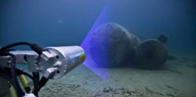
1 - 3D at Depth, Inc. - 3D at Depth LiDAR underwater scanner
“3D at Depth” is a leading provider of advanced subsea LiDAR (Light Detection
and Ranging) systems and data services, which is part of the “Kraken Robotics”
group. They specialize in delivering precise underwater measurement and
mapping solutions for demanding offshore industries like oil & gas, renewables
, and marine construction.
Website: https://www.krakenrobotics.com/services/lidar-solutions/
Email: info@3datdepth.com
Adress: 1550 Dewey Avenue Boulder, CO 80304, USA
2 - 3D at Depth, Inc. - Advanced Subsea LiDAR for Rapid Underwater
Mapping
See above the description of “3D at depth” company
Note: LiDAR (Light Detection and Ranging), is a remote sensing method that
uses laser light to create a 3D representation of the surrounding
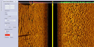
environment.

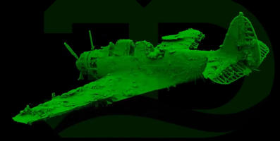
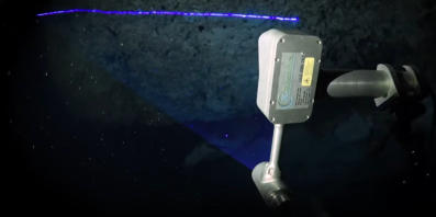
3 - 3D at Depth, Inc. - Preserving History: US Navy Douglas TBD-1
Devastator
See above the description of “3D at depth” company
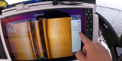
Note: This video shows how photogrammetry, when combined with LiDAR,
can be used to record the exact proportions of an immersed object and
display them in a 3D image that can be rotated in any direction.
6 - Applied acoustics - Mini beacon charging and channel configuration
(1000 and 1100 Series) with 1082 Smart Switch
See above the description of “Applied Acoustics” company
Note: This video is the second of the series mentioned above
5 - Applied Acoustics - Micro beacon charge and channel configuration
(models 1219A, 1319A 1329A)
“Applied Acoustics” is a leading manufacturer of subsea equipment, including
acoustic releases, transponders, and beacons.
This document is the first of a series of configuration guides for setting up their
micro beacons, which are used for underwater tracking and positioning.
Website: https://www.appliedacoustics.com/
Email: enquiries@appliedacoustics.com
Adress: Unit 7, Nimbus Park, Oldends Lane, Stonehouse, Gloucestershire
GL10 3SU United Kingdom
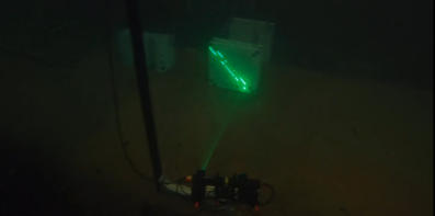
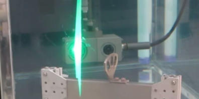
7 - Applied acoustics - 03. Battery replacement- 1000 and 1100 series Mini
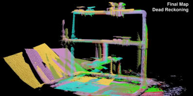
beacon
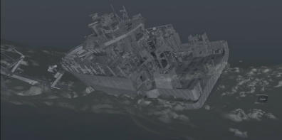
See above the description of “Applied Acoustics” company
Note: This video is the second of the series mentioned above
8 - Applied acoustics - 04. Battery replacement- 1200 and 1300 series Micro
beacon
See above the description of “Applied Acoustics” company
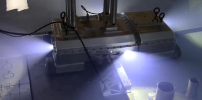
Note: This video is the second of the series mentioned above
9 - Applied acoustics - 05. How to set up your Alpha USBL system
See above the description of “Applied Acoustics” company
Note: This video is the second of the series mentioned above
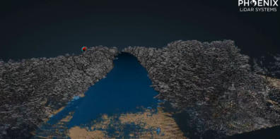
10 - Applied acoustics - 06. How to set up your Alpha Portable USBL system
See above the description of “Applied Acoustics” company
Note: This video is the second of the series mentioned above

11 - Applied acoustics - 07. How to set up your Nexus Lite USBL system:
Hardware
See above the description of “Applied Acoustics” company
Note: This video is the second of the series mentioned above
13 - Curtin HIVE - Photogrammetric 3D Model of the stern of HMAS AE1
wreck reconstructed from thousands of photographs
Curtin HIVE specializes in creating precise 3D digital models and visualizations
for research, including maritime archaeology. Their work on the HMAS AE1
wreck is a perfect example of their expertise.
Website: https://hive.curtin.edu.au/
Curtin University website: https://www.curtin.edu.au/
YouTube Chain: https://www.youtube.com/@curtinhive
Adress: Curtin University, Kent Street, Bentley, Perth Western Australia 6102
Australia
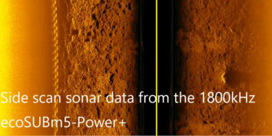
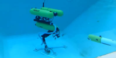
14 - EcoSub Robotics - Side Scan Sonar Data from ecoSUBm5-Power
“ecoSUB” is a pioneering technology company developing autonomous
underwater vehicles (AUVs) designed to make marine data collection easy to
use and financially affordable.
This video shows how a portable autonomous vehicle, capable of carrying
sensors for data collection, such as the ecoSUBm5-Power, can be used for
mapping with side-scan sonar.
Website: https://www.ecosub.uk/
Address: National Oceanography Centre, European Way
Southampton, SO14 3ZH, United Kingdom
Email: enquiries@ecosub.co.uk
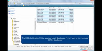
15 - Quality Positioning Services B.V. (QPS) - How-To: USBL Calibration
“QINSy (Quality Integrated Navigation System)” is a leading software suite for
hydrographic surveying, offshore construction, and dredging.
The "USBL Calibration" how-to video is a classic piece of technical support and
educational content produced by QPS for its users, as calibrating a USBL (Ultra-
Short Baseline) acoustic positioning system is a critical step for ensuring accurate
data collection.
Website: https://qps.nl/
Address: Hengordus 41, 4824 AD Breda, The Netherlands
Email: info@qps.nl
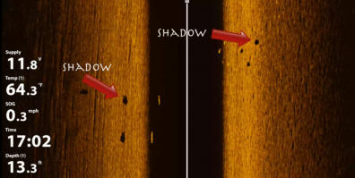
16 - Humminbird - What is Side Imaging and how to read it
“Humminbird” is an American manufacturer of quality marine electronics,
specializing in fishfinders, sonar technology, chartplotters, and marine radar
systems.
This video shows how a portable imaging sonar can be used effectively to map
a specific area.
Website: https://www.humminbird.com
Address: Johnson Outdoors Marine Electronics, Inc.
1 Humminbird Lane, Eufaula, AL 36027, USA
17 - Humminbird - How to interpret Side Imaging Sonar
“Humminbird” company is described above
This video can be considered the continuation of the one above.
18 - Humminbird - What is MEGA 360 Imaging & how to read it
“Humminbird” company is described above.
The Humminbird MEGA 360 is a Sonar system with a transducer rotating 360
degrees, providing a complete, bird's-eye view of the underwater environment
around the boat it is installed on. While primarily designed for fishing, this
system has obvious applications in mapping and on-time worksite monitoring.
19 - Marine Sonic Technology - Sea Scan Survey Software
"Marine Sonic Technology (MST)" is a manufacturer renowned for its high-
resolution towed side-scan sonar systems, specifically designed for professional,
scientific, and commercial applications where extreme detail and accuracy are
critical.
The "Sea Scan Survey Software" is the data-acquisition and processing software
developed specifically for use with the company's line of side-scan sonar
systems. It is used to control the sonar, record data, and create sonar mosaics.
Website: http://www.marinesonic.com/
Address: 2366 Schooner Drive, Whiteford, Maryland 21160, USA
Email: info@marinesonic.com
20 - Simrad - Sonar for Dummies: Side Scan setup
Simrad is a division of Navico company, specializing in marine electronics,
including sonar, fish finders, chartplotters, and autopilots.
While not initially intended for commercial users, this video is a good tutorial for
people not accustomed to such equipment, and therefore discovering their
purpose.
Website: https://www.simrad-yachting.com
Address: 2210 Corridor Park Drive, Suite 100, Nashville, TN 37214, USA
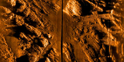
21 - Sonardyne International Ltd. - Solstice side scan sonar
“Sonardyne” is a UK-based company known for developing advanced
underwater acoustic, inertial, and optical systems for offshore energy, science,
and defense applications. The "Solstice" is their specific brand of side scan sonar
Website: https://www.sonardyne.com/
Address: Yateley, Hampshire, GU46 7GD - United Kingdom
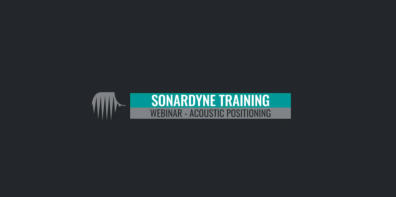
22 - Sonardyne International Ltd. - Acoustic Positioning Principles
“Sonardyne” company is described above
This video is the 1st module of a 7-part training webinar series.
23 - Sonardyne International Ltd. - Principles of USBL
“Sonardyne” company is described above
This video is the 2nd module of a 7-part training webinar series.
24 - Sonardyne International Ltd. - Principles of LBL
“Sonardyne” company is described above
This video is the 3rd module of a 7-part training webinar series.
25 - Sonardyne International Ltd. - Principles of INS
“Sonardyne” company is described above
This video is the 4th module of a 7-part training webinar series.
26 - Sonardyne International Ltd. - Sparse LBL
“Sonardyne” company is described above
This video is the 5th module of a 7-part training webinar series.

27 - Sonardyne International Ltd. - SLAM
“Sonardyne” company is described above
This video is the 6th module of a 7-part training webinar series.

28 - Sonardyne International Ltd. - CASIUS
“Sonardyne” company is described above
This video is the last module of a 7-part training webinar series.
29 - Sonardyne International Ltd. - Fusion 2: Combined LBL and INS
Software
“Sonardyne” company is described above
Fusion 2 is a sophisticated navigation software suite from Sonardyne that tightly
combines two positioning technologies:
- LBL (Long Baseline): A network of acoustic transponders on the seafloor that
provides a highly accurate, absolute position reference.
- INS (Inertial Navigation System): A system that uses gyroscopes and
accelerometers to provide smooth, high-update-rate relative motion and
heading.
By fusing these two data sources, Fusion 2 delivers a highly robust and
continuous navigation solution for underwater vehicles (AUVs, ROVs) that is
resistant to acoustic dropouts and provides exceptional accuracy.
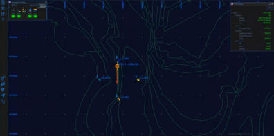
30 - Sonardyne International Ltd. - Micro Ranger 2 USBL: Whats New
“Sonardyne” company is described above
The Micro Ranger 2 is a compact USBL system designed for underwater
positioning applications. It is rugged, easy to transport and deploy, provides
accurate 3D position data, with a typical accuracy of <0.2% of range (e.g., 20
cm at 100 m range), provides real-time position data, can track multiple targets
simultaneously, and can be configured to work with a range of underwater
vehicles, ROVs, AUVs, or other equipment.
This video is the 1st module of a 5-part training webinar series on this
equipment.
31 - Sonardyne International Ltd. - Micro Ranger 2 USBL: How To Set Up
Your Hardware
“Sonardyne” company is described above
This video is the 2nd module of a 5-part training webinar series on this
equipment.
32 - Sonardyne International Ltd. - Micro Ranger 2 USBL: How To Set Up
Your Software
“Sonardyne” company is described above
This video is the 3rd module of a 5-part training webinar series on this
equipment.

33 - Sonardyne International Ltd. - Micro Ranger 2 USBL: Shallow water
tracking
“Sonardyne” company is described above
This video is the 4th module of a 5-part training webinar series on this
equipment.
34 - Sonardyne International Ltd. - Micro Ranger 2 USBL: Change tracking
update rate
“Sonardyne” company is described above
This video is the 5th module of a 5-part training webinar series on this
equipment.
35 - Sonardyne International Ltd. - Subsea Transponder Care: Post
Deployment
“Sonardyne” company is described above
This video provides clear, step-by-step instructions on post-deployment
procedures for maintaining and preserving acoustic transponders once they
have been recovered from the seabed.
36 - Sonardyne International Ltd. - Positioning principles: What is USBL
“Sonardyne” company is described above
This video aims to provide a foundational understanding of this positioning
subsea tool to new engineers, surveyors, clients, and students in the offshore
energy, ocean science, and defense sectors.


Click on the
octopus to return to
the top of the page
12 - Ocean alliance project - Basic metashape workflow underwater
photogrammetry
Ocean Alliance Project (OAP) is a nonprofit organization based on O‘ahu,
Hawaii. Their mission is to protect and preserve the marine biodiversity of coral
reefs.
Youtube channel: www.youtube.com/@oceanallianceproject
Website: https://oceanallianceproject.org/
Address: 420 Nahua Street, Honolulu, HI 96815, USA
Email: dylan@oceanallianceproject.org
The purpose of this video is to walk viewers through a workflow in "Agisoft
Metashape", a professional photogrammetry and 3D reconstruction
software used to turn photographs or videos into accurate 3D models, point
clouds, meshes, Digital Elevation Models (DEM), and orthomosaics applied
to underwater imagery.
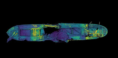
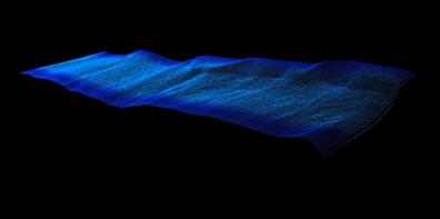
4 - 3D at Depth, Inc. - Underwater LiDAR archiological scann Devastator
plane
See above the description of “3D at depth” company
Note: This video shows how the U.S. Navy Douglas TBD Devastator torpedo
bomber above appears when LiDAR is used alone.
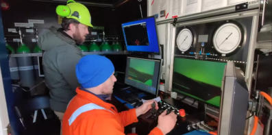
37 - Universitat de Girona - 3 D laser scanner for underwater manipulation
This work, which makes precise manipulation possible by correcting the optical
distortions caused by water refraction, comes from the VICOROB institute at the
University of Girona, a leading center in underwater robotics.
Address: Plaça Sant Domènec, 3, Edificio Les Àligues, 17004 Girona, Catalogna,
Spain
Phone: +34 972 418 046
Email: informacio@udg.edu
Website: https://www.udg.edu/en
38 - Universitat de Girona - Inspection of an underwater structure using
point cloud SLAM with an AUV and Laser
Scanner
The Universitat de Girona is described above
This video describes a method for underwater inspection where an
Autonomous Underwater Vehicle (AUV) equipped with a laser scanner collects
high-resolution 3D point clouds of subsea structures. This process uses point
cloud SLAM (Simultaneous Localization and Mapping) to create detailed virtual
maps of underwater assets, enabling precise inspection even at significant
depths. The laser scanner operates by time-of-flight measurement of laser pulses,
allowing millimetric-resolution 3D data collection.
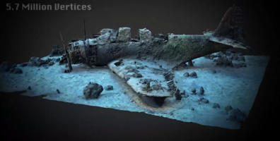
39 - Voyis - 3D point Cloud Model of the Bluesfields shipwreck
Voyis (formely 2G Robotics) is a Canadian company specializing in underwater
optical imaging and laser scanning technologies.
Headquarters: 120 Randall Drive, Unit E, Waterloo, ON N2V 1C6 - Canada
Parent company: Covelya Group
Website: https://voyis.com
Phone: +1 (519) 489-0005
This video is a digital 3D scan of a sunken ship, made from data points:
The shipwreck appears as millions of tiny dots floating in space, each with a
precise 3D coordinate, that together form the full shape of the wreck.
40 - Voyis - Underwater Imaging and laser scanners
Voyis company is described above.
This video explains how laser scanner are used to capture detailed underwater
images and measurements where visibility and access are limited.
41 - Voyis - Cave scanning with an underwater laser scanner - 3D mapping
with lasers!
Video authors: Stephen Daire, Marcelin Nebenhaus, Nathalie Gibb
This video showcases the use of laser scanning technology to create detailed
3D maps of underwater cave systems.
42 - Voyis - Underwater Laser Scanning - Bridge Scour Experiments and
Sediment Analysis
This video demonstrates how scanning helps researchers evaluate sediment
deposition or removal to quantify changes in bed elevation and shape over
time. Therefore, it proves that this technology can be used to support safer
bridge design and maintenance strategies.
43 - UVision ApS - Revolutionizing Underwater Inspection UVision 3D
Scanning solution
UVision ApS specializes in the development of underwater 3D scanning systems
for inspection and digital twin generation. It is involved with the European
Space Agency
Headquarters address: Højbro Plads 10
1200 Copenhagen Denmark
Website: https://uvision.dk
Mail: mortenbeier@uvision.dk
+45 26 80 01 31
This video highlights the capabilities and advantages of the UVision 3D scanning
solution. Note that this system is not a LASER scanner, but an underwater 3D
photogrammetry / stereo-vision camera-based system.
44 - Robotics group at Julius-Maximilians-Universität Würzburg -
Towards an Underwater 3D Laser Scanning System for Mobile
Mapping
Robotics group at Julius-Maximilians-Universität Würzburg is located at the
Hubland Campus (South), Würzburg, Germany, and is part of the university’s
Department of Computer Science
Website: https://www.informatik.uni-wuerzburg.de/robotics/
Email: l-info17@informatik.uni-wuerzburg.de
This video presents a prototype system for creating high-resolution 3D maps
underwater using laser scanning. Its main goal is to enable mobile mapping,
meaning the scanner can move while capturing 3D data.
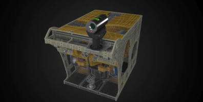
45 - Newton Labs - M200UW Underwater Laser Scanner Demonstration
Newton Labs is a U.S.-based technology company specializing in advanced
machine vision, underwater laser scanning, and robotic inspection systems,
headquartered in Renton, Washington. They provide solutions for nuclear
power, marine, aerospace, and industrial sectors.
Headquarters: 11521 183rd Place SW, Renton, Washington 98055, USA
Website: https://www.newtonlabs.com/
Email: info@newtonlabs.com / sales@newtonlabs.com
Youtube channel: youtube@newtonlabs5882
This video demonstrates that the M200UW laser scanner can create highly
accurate 3D models underwater and can be used for vessel inspection, nuclear
reactor internals scanning, and pipeline and various structures measurements.
46 - Newton Labs - Underwater Robot - Nuclear Inspector
Newton Labs is described above.
This video, which complements the one from the same company mentioned above,
showcases the M200UW laser-scanner robotic inspection system, which has been
adapted for inspecting nuclear reactor vessels.
47 - Norsk Remote sensing - Shipwerck scaning (LiDAR)
Norsk Remote Sensing utilizes LiDAR technology alongside innovative Digital
technology to acquire accurate, detailed data on any subject or location.
Headquarters: Southwest Washington state - USA
Website: https://norskrs.com/
Email: norskscanning@gmail.com
Youtube channel: @NORSKscanning
This video shows how a recently sunken small vessel appears through the
technologies used to detect it.
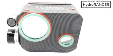
48 - Phoenix LiDAR Systems - Introducing hydroRanger from phoenix
LiDAR systems
Phoenix LiDAR Systems specializes in advanced airborne LiDAR mapping
solutions, including bathymetry
Headquarters: 2113 Wells Branch Pkwy Suite 4000, Austin, TX 78728, USA
Website: https://phoenixlidar.com/
Phonel: +1 (323) 577-3366
This video presents the hydroRanger, an aerial system specifically designed for
bathymetric surveys.
49 - Phoenix LiDAR Systems - Lidar mapping through water with
HydroRanger
Phoenix LiDAR Systems company is described above
This video shows the capabilities of the hydroRanger bathymetric system described
in the video above.
50 - INSITE Solution / NV5 Geospatial - Scott Venables Interview:
Capturing Underwater Geospatial Data using Lidar
INSITE Solution is a company that develops cloud-based, geospatially enabled
data management platforms.
Headquarters: 208 N. Market St., Suite 175, Dallas, TX 75202, USA
Website: https://insite.net
Email: info@insite.net
Phone: +1 (214) 800-4333
NV5 Geospatial provides comprehensive geospatial solutions, including:
Airborne LiDAR and topobathymetric surveys, remote sensing for environmental
monitoring, infrastructure planning, and coastal management, and end-to-end
services from data acquisition to analytics and visualization.
Headquarters: 200 South Park Road, Suite 350, Hollywood, FL 33021, USA
Website: https://www.nv5.com/geospatial
Phone: +1 (954) 495-2112
Scott Venables is an Account Manager at NV5 Geospatial, a leading provider of
end-to-end geospatial solutions.
In this interview, he highlights how topobathymetric LiDAR technology enables
precise mapping of underwater and near-shore environments, offering new
capabilities for geospatial data collection in flooded areas, coastal zones, and
shallow waters.