


Implement Photogrammetry in Commercial Diving
& ROV Operations: A Resource Guide (Page 3 of 3)


Videos and animations, including process presentations,
project showcases, and online courses.

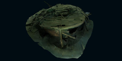
1 - Fours and Sixes Wreck Shipwreck 3D Photogrammetry
This video, published by Sketchfab company, shares a digital reconstruction of
an unidentified wreck located in Lake Union just in front of downtown Seattle
near an active marina, making it accessible for underwater-heritage
documentation, study, and public viewing.
It can also be downloaded at this address: https://sketchfab.com/3d-models/
fours-and-sixes-wreck-fdbb1c96d053425ab7d67c0901be618a
Sketchfab is an online platform dedicated to making 3D a mainstream media
format, to publish, share, discover, buy, and sell interactive 3D content directly
on the web. It functions as a significant community hub and marketplace for a
diverse group, including artists, engineers, museums, game studios, and others.
Website: https://sketchfab.com/
Adress: 440 9th Ave, Suite 1700, New York, NY 10001 - USA
3 rue d’Uses 75002 paris - France
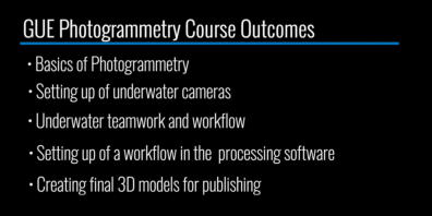
2 - Global Underwater Explorers (GUE): Photogrammetry Course
This video presents the training course from Global Underwater Explorers (GUE),
which introduces divers to underwater photogrammetry. It covers topics
including basics of photogrammetry, setting up underwater cameras, proper
underwater teamwork and workflow, and how to process imagery to generate
publishable 3D models.
Global Underwater Explorers TV (https://www.youtube.com/@GUEdivers)
is the media production channel of GlobalUnderwater Explorers (GUE), a
nonprofit committed to high-quality divereducation and to exploration and
conservation of the world’s aquatic environments.
Website: https://www.gue.com/
Email: qc@gue.com
Phone: +1 (386) 454-0820
Adress: 18487 High Springs Main Street, High Springs, FL 32643, USA
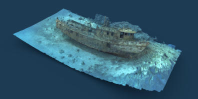
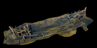
3 - Mr. Bud Shipwreck, Roatan, Honduras Photogrammetry
This video is an assembly of 4 videos that show progressive stages of a
photogrammetry workflow applied to a shipwreck site. Note that the steps are
not explicitly mentioned, but are clearly identifiable.
- The “Sparse Cloud” phase is the initial point-cloud alignment from photos.
- The “Dense Cloud” phase is the refinement of the 1st phase. The “Mesh” phase
shows the stage in the photogrammetry workflow where a polygonal mesh is
generated from the previously computed 3D point cloud.
- In the last phase, after generating a dense point cloud, the software connects
points into triangular faces (mesh) to form a continuous surface, effectively
“points” into “solid geometry”, and the “Textured 3D model” presents the final
textured 3D reconstruction.
The 3D model based on these videos (and the underlying photogrammetry
data) is available on Sketchfab, titled “Mr. Bud Shipwreck, Roatan, Honduras”.
The author is Patric Lengacher, who can be found on his Sketchfab page:
https://sketchfab.com/3d-models/mr-bud-shipwreck-roatan-honduras-
306ace67dde940b497b94fa440a5e975
4 - Photogrammetry demo in Agisoft Metashape
This video is a tutorial on the photogrammetric workflow in Metashape
software, showing how images can be aligned and processed to reconstruct a
3D scene from 2D photos.
Agisoft Metashape is a commercial photogrammetry solution that supports 3D
model creation, textured meshes, and orthomosaics. It ranks at the top of our
directory of software solutions, as it is widely used in underwater archaeology,
marine biology, mapping, and survey projects, and has strong academic
references. It is developed by Agisoft LLC, a company founded in 2006
Adress: 64 Kirochnaya Street, St. Petersburg, Russia, 191015
Phone: +7 (812) 621-33-41
Website: https://www.agisoft.com/
Email: Email: info@agisoft.com

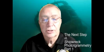
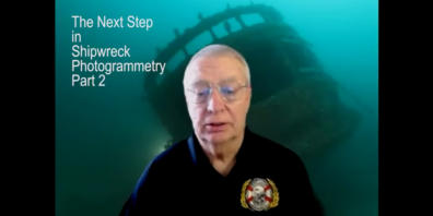
5 - The Next Step in Shipwreck Photogrammetry Tutorial - Part 1 & 2
This is a tutorial series focused on underwater shipwreck photogrammetry on,
how to use photographic data to reconstruct accurate three-dimensional
models of shipwreck sites. This video series is dedicated to viewers who already
have a basic understanding of photogrammetry and want to take their skills to
the next level specifically for shipwreck documentation.
These videos were authored by Kenneth Merryman, who also publishes them
on his channel ( https://www.youtube.com/@kennethmerryman3758 )
6 - Photogrammetry Wreck with ROV
This video, published by LA Survey AB, demonstrates how imagery captured by
a remotely operated vehicle(ROV) is used to generate a 3D model of an
underwater shipwreck and how this 3D representation can be used to observe
this ship wreck in its entirety and also allows the viewer to zoom in on particular
parts of the object studied.
Company creator: Linus Andersson
Email: linus@la-survey.se
Address: Skogsviksvägen 52B 423 61, Torslanda, Västra Götaland Sweden
YouTube channel: https://www.youtube.com/@lasurveyab7741
7 - S.L. Dowell Shipwreck 3D Photogrammetry
This video documents a 3D photogrammetric model of the S.L. Dowell
shipwreck, awooden tugboat wreck that is frequently used by divers as an
accessible photogrammetry project target in the Seattle area.
Video by Kees Beemster Leverenz
Email: Kees@GUE.com
Website: https://www.keesbl.com/
YouTube channel: https://www.youtube.com/@KeesBL

The videos below have been publicly released by organizations and
enthusiasts involved in photogrammetry to promote this technology.
Please note that the names and contact details of the authors and
publishers are included, so you can reach out to them if you wish.
Websites Promoting Photogrammetry

There are many websites about photogrammetry, so it’s impossible to
list them all. Also, keep in mind that new sites appear and others
disappear daily. This presentation aims to show how they can be
classified according to your needs to make searching easier. In this
example, the websites are grouped into three categories: “Operational
partners,” “Educational and Scientific Resources,” and “Media,
Inspiration, and Public Engagement Resources.” Note that, despite the
quality of the sites selected for this brief directory, your search for
partners and resources should not be limited to them.
1 - Operational Partners
These are commercial companies that provide the operational tools needed
for underwater photogrammetry, such as ROVs, cameras, sensors, and
integrated imaging systems, along with practical guidance, workflows, and
support for using those tools effectively.
VOYIS:
Voyis is a Canadian company specializing in advanced subsea cameras, laser
scanners, and imaging solutions for ROVs and AUVs. It is headquartered at 120
Randall Dr, Unit E Waterloo, ON N2V 1C6.
- Website: https://voyis.com/understanding-underwater-photogrammetry/
The Voyis webpage “Understanding Underwater Photogrammetry” is an educational
article that explains the fundamentals of underwater photogrammetry, its
challenges, and its applications, while also showcasing how Voyis’ subsea imaging
systems support accurate 3D reconstructions.
Deep Trekker:
Deep Trekker is an observation ROV manufacturer, headquartered at 155 Washburn
Drive, Kitchener, ON, Canada N2R 1S1, already cited on our website.
- Website: https://support.deeptrekker.com/cameras-and-recording/recording/
photogrammetry-guide
- Website: https://www.deeptrekker.com/resources/rovs-for-3d-photogrammetric-
modeling
The purpose of the Deep Trekker support page “Photogrammetry Guide” is to
provide a step-by-step tutorial for ROV users on how to capture underwater
images and generate accurate 3D models using photogrammetry software. It is
aimed at beginners and emphasizes practical tips for data acquisition, equipment
setup, and model generation.
The Deep Trekker webpage “ROVs for 3D Photogrammetric Modeling” is a resource
page that explains how Deep Trekker’s ROVs can be used to capture underwater
imagery for photogrammetry, highlighting their features, workflows, and industry
applications. It complements, but is not strictly a continuation of the
“Photogrammetry Guide” page
Blueye Robotics:
Blueye Robotics is a Norwegian company specializing in compact, user‑friendly
underwater drones designed for inspections, research, and exploration. It is
headquartered at Transittgata 10, Trondheim, 7042, Norway, MVA 915 666 450
- Website: https://www.blueyerobotics.com/blog/create-3d-models-of-your-
underwater-assets
The Blueye Robotics blog page “Create 3D Models of Your Underwater Assets”
explains how underwater photogrammetry can be performed using Blueye’s ROVs,
guiding users through the process of capturing images and generating 3D
reconstructions.
Blue Atlas Robotics:
Blue Atlas Robotics is a Danish company, headquartered at Landbrugsvej 6 5260
Odense Denmark, specializing in subsea automation, robotic inspections, and
marine data visualization.
- Website: https://blueatlasrobotics.com/create-3d-models-of-your-underwater-
assets-with-photogrammetry
The Blue Atlas Robotics webpage “Create 3D Models of Your Underwater Assets
with Photogrammetry” explains how their ROV technology enables high-resolution
underwater inspections and 3D reconstructions.
DeepWater Exploration (DW):
DW (DeepWater Exploration Inc.) is a privately held subsea technology company
founded in 2022, headquartered at 6215 Ferris Square, Ste 140 San Diego, CA
92121.
- Website: https://dwe.ai/blogs/news/unlocking-the-depths-the-future-of-
underwater-photogrammetry-and-3d-reconstruction
The purpose of the DWE.ai blog page “Unlocking the Depths: The Future of
Underwater Photogrammetry and 3D Reconstruction” is to explain how advances in
underwater imaging and photogrammetry are revolutionizing subsea exploration,
while positioning DeepWater Exploration (DW) as a leader in subsea vision
technologies. DW’s activities focus on developing next-generation underwater
cameras, optics, and computer vision systems to support marine robotics,
autonomy, and industrial inspections.
PIX4D - Diving into Underwater Photogrammetry:
Pix4D S.A. is a company specialized in mapping solutions and 3D models,
headquartered Route de Renens 24, 1008 Prilly, Switzerland
- Website: https://www.pix4d.com/blog/diving-into-underwater-photogrammetry/
The purpose of the Pix4D blog article “Diving into Underwater Photogrammetry” is
to explain how photogrammetry techniques are being adapted for underwater
environments, highlighting challenges, innovations, and applications in fields like
archaeology, environmental monitoring, and infrastructure inspection.
It introduces readers to the concept of underwater photogrammetry, explaining
why mapping beneath the ocean surface is difficult (light refraction, color loss,
visibility issues), and details new acquisition methods (distance-based image
triggering rather than time-lapse) that improve accuracy and efficiency in
underwater image collection.
It demonstrates how Pix4Dmapper software can process underwater imagery into
accurate 2D maps and 3D reconstructions, positioning Pix4D as a leader in
photogrammetry solutions.
2 - Educational, Scientific, and Methodological Resources
These are organizations providing credible knowledge, training, standards,
and scientific context that help companies build a photogrammetry
department with rigor and relevant practices.
NOAA- Ocean Exploration - Photogrammetry:
The National Oceanic and Atmospheric Administration (NOAA) is a scientific agency
within the United States Department of Commerce. Its primary purpose is to
understand and predict changes in the Earth's environment, particularly relating to
the oceans, atmosphere, and climate, and to share this knowledge with the public,
other government agencies, and the international community.
- Website: https://oceanexplorer.noaa.gov/technology/photogrammetry/
The purpose of NOAA’s Ocean Exploration photogrammetry webpage is to educate
the public and professionals about how photogrammetry is used in ocean science
and archaeology, highlighting its role in creating accurate 3D models of underwater
sites for research, preservation, and public access
American Society for Photogrammetry and Remote Sensing
(ASPRS):
The American Society for Photogrammetry and Remote Sensing (ASPRS) is a U.S.
nonprofit scientific association dedicated to advancing the fields of
photogrammetry, remote sensing, and geospatial science. It is headquartered at
8550 United Plaza Blvd, Suite 1001, Baton Rouge, LA 70809, USA
- Website: https://www.asprs.org/
Its website serves as the central hub for professional resources, publications,
certifications, events, and community engagement.
Global Underwater Explorers - GUE Photogrammetry:
GUE, is a nonprofit dedicated to advancing scuba diving education, exploration, and
conservation through standardized training. The organization is also described in
the directory of training establishments.
- Website: https://www.gue.com/diver-training/explore-gue-courses/recreational
/photogrammetry
The purpose of the Global Underwater Explorers (GUE) photogrammetry course
webpage is to introduce divers to the fundamentals of underwater
photogrammetry, explain the skills taught in the course, and encourage enrollment
in GUE’s structured training programs.
Sea Imagination:
Sea Imagination is a creative and technology-driven initiative focused on ocean-
themed storytelling, education, and digital solutions that combine marine science,
archaeology, and advanced imaging. This organization is headquartered at Ahtri 12,
10151 Tallinn, Estonia.
- Website: https://seamagination.com/underwater-photogrammetry/
- Website: https://seamagination.com/how-to-get-started-with-underwater-
photogrammetry/
The purpose of its website is to share projects, articles, and resources that blend
marine exploration with imagination, aiming to inspire curiosity about the
underwater world while offering software and design services.
USGS (U.S. Geological Survey):
The United States Geological Survey (USGS) is a U.S. government science agency
that provides impartial, authoritative data on the nation’s natural resources, hazards,
and landscapes. It is part of the Department of the Interior and serves as a
trusted source of earth science for decision-makers, researchers, and the public.
- Website: https://www.usgs.gov/centers/whcmsc/news/underwater-
photogrammetry-reaches-new-depths-0
The purpose of the USGS Woods Hole Coastal and Marine Science Center news
page “Underwater Photogrammetry Reaches New Depths” is to inform the public
and scientific community about advances in underwater photogrammetry research,
showcasing how USGS scientists are using this technology to study and preserve
marine environments.
UVISION:
UVision is a Danish company specializing in underwater 3D scanning solutions,
combining computer vision research with practical inspection tools for marine and
industrial applications. It is headquartered in Copenhagen, Denmark (Højbro Plads
10, 1200 København K).
- Website: https://uvision.dk/articles/photogrammetry/what-is-underwater-
photogrammetry/
The purpose of the UVision article is to explain what underwater photogrammetry
is, how it works, and why it matters, while also showcasing UVision’s own
technology contributions in this field.
3 - Media, Inspiration, and Public Engagement Resources
These organizations provide storytelling, heritage content, visual inspiration,
and community engagement, but not operational or methodological guidance.
WW2 Wrecks.com:
WW2Wrecks.com is a specialized online platform dedicated to documenting,
researching, and sharing stories about WWII wrecks worldwide. WW2Wrecks.com
is not a formal corporation with a public office address. It is likely run by a small
editorial team or individual historian(s).
- Website: https://www.ww2wrecks.com/portfolio/photogrammetry-documenting-
ww2-wrecks-in-3d/
The WW2Wrecks.com webpage “Photogrammetry – Documenting WW2 Wrecks in
3D” presents underwater photogrammetry as a powerful tool for preserving and
studying World War II shipwrecks.
Mozaik UW Cameras:
Mozaik is a Canadian-U.S. based company specializing in underwater cameras,
housings, strobes, and video lights, serving divers and photographers worldwide.
Its is headquartered at unit 104-7728 128th Steet, Surrey, BC V3W1L3 Canada.
- Website: https://www.housingcamera.com/blog/underwater-photography/diving-
into-history-the-evolution-of-underwater-photography
The Housing Camera.com blog page “Diving into History: The Evolution of
Underwater Photography” provides an educational overview of how underwater
photography has developed over time.
Atlas Obscura - “How a 19th-Century Biologist Became an
Underwater Photography Pioneer”:
Atlas Obscura is global community characterized by its collective passion for
exploration.
- Website: https://www.atlasobscura.com/articles/worlds-first-underwater-portrait
The purpose of the Atlas Obscura article is to tell the story of Louis Boutan, a 19th-
century French biologist who pioneered underwater photography, explaining how his
experiments and inventions made possible the world’s first clear underwater
portraits and scientific images.
Darkocean:
DarkOcean is a marine technology and survey company with offices in Qatar, UAE,
Saudi Arabia, India, and the UK. It is involde in the following activities:
•
Hydrographic surveys (mapping seafloor and coastal areas).
•
Seismic surveys for subsurface exploration.
•
Subsea and seabed surveys for infrastructure and environmental monitoring.
•
Positioning and navigation systems.
•
Geophysical data collection and analysis.
•
Integration of photogrammetry into marine exploration workflows.
- Website: https://www.linkedin.com/pulse/underwater-photogrammetry-
revolutionizing-marine-exploration-kurvf/
The LinkedIn article’s purpose is to highlight how underwater photogrammetry is
transforming marine exploration, while DarkOcean’s activities center on advanced
subsea survey services, underwater robotics, and geo-intelligence solutions for
industries such as energy, infrastructure, and marine research.


Click on the
octopus to return to
the top of the page